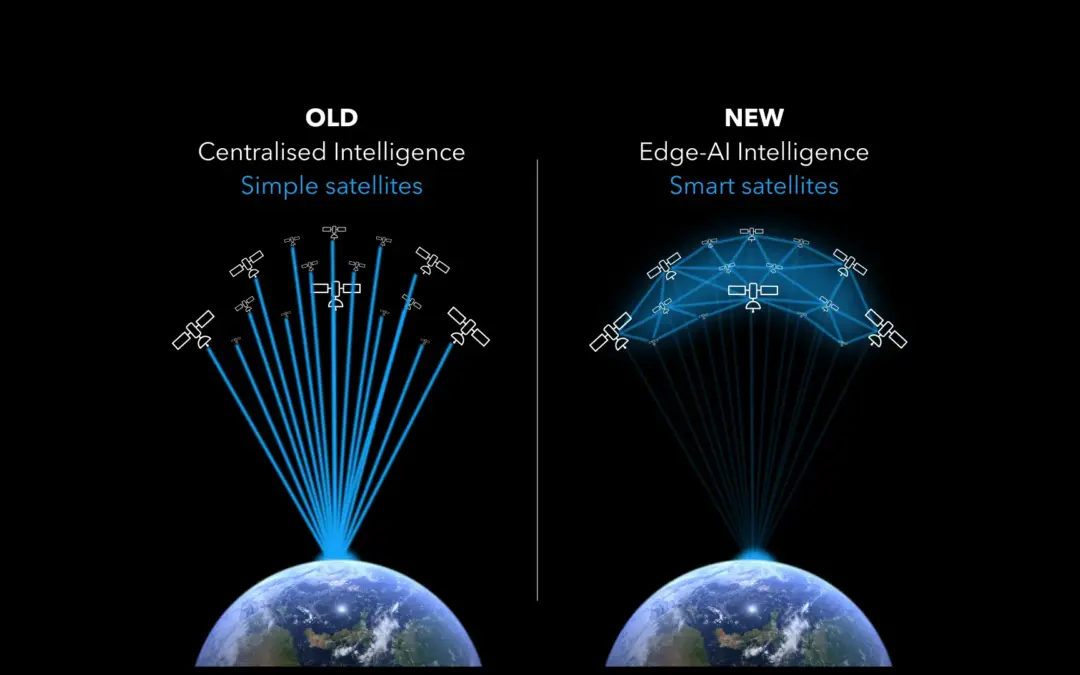
In the landscape of satellite technology, we are witnessing a pivotal transition from the conventional centralized model to a cutting-edge framework of edge AI. Traditional “simple” satellites give way to efficient, autonomous, intelligent AI-powered counterparts. This shift to AI operating in space allows for collaborative operations and optimizes space activities, turning satellites into proactive decision-makers. With real-time analytics and communications, AI-powered satellites are becoming crucial in sectors like security, commerce, and sustainability, where immediate and accurate data delivery is invaluable to humanity.
THE PLATERO MISSION BY OPEN COSMOS
One upcoming mission, the PLATERO mission by Open Cosmos, scheduled to launch aboard the upcoming SpaceX Transporter 9 mission in November 2023, will demonstrate the power of AI in space. The PLATERO satellite, funded by the Junta de Andalucía through the Andalusian Agricultural and Fisheries Management Agency (AGAPA), integrates Earth Observation (EO), Internet of Things (IoT) connectivity, and Artificial Intelligence(AI) powered by Ubotica, for enhanced environmental monitoring.
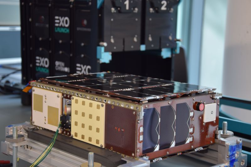
The PLATERO Satellite
PLATERO will track biodiversity, desertification, emergencies (e.g., wildfires, floods), and farming impacts, aiding sustainable policy development. Equipped with a high-performance multispectral camera and IoT capabilities, PLATERO enables real-time, ground-based sensor communication, streamlining decision-making.
COMBINING AI, EO AND IOT IN SPACE
The combination of Earth Observation (EO), the Internet of Things (IoT), and SPACE:AI by Ubotica, transforms satellites into providers of Live Earth Intelligence.
Imagine a scenario where an IoT sensor network is deployed across a stretch of ocean or a large lake. These sensors can detect anomalies that could indicate environmental hazards—such as sudden increases in bilge discharge from ships or the early formation of harmful algal blooms.
Upon detecting such potential threats, the IoT system sends an immediate alert to an AI-equipped satellite. This satellite, with its high-resolution imaging capabilities, swiftly orients to capture detailed imagery of the affected area. Onboard SPACE:AI, trained in image recognition and pattern analysis, processes this data in real-time to immediately identify hazard signs, such as oil slick patterns characteristic of bilge discharge or the distinct colouration of an algal bloom.
With the precise location and nature of the event confirmed, the satellite system can then communicate this information back to Earth. The relevant authorities receive actionable notifications, complete with imagery and an analysis of the potential hazard. This enables a rapid response—whether that is dispatching cleanup crews to the site, alerting nearby vessels to avoid the area, or initiating closer monitoring to track the development of the situation.
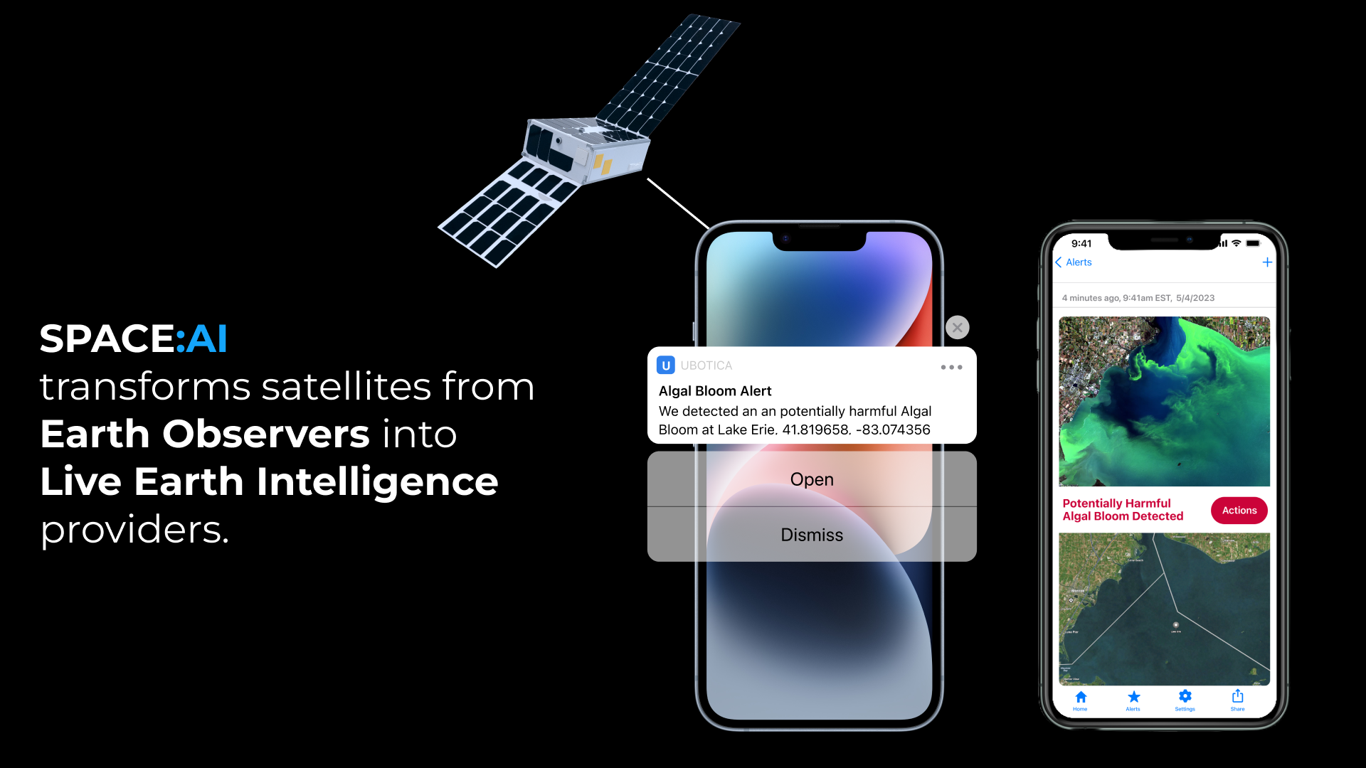
The integration of IoT, EO, and SPACE:AI delivers Live Earth Intelligence—turning real-time data into actionable insights. This fusion not only accelerates the detection and response to specific environmental hazards, such as water contamination, but also empowers proactive monitoring and protection of water resources. Unlike traditional methods that react slower, this AI-powered system swiftly identifies, analyses, and provides precise intelligence to mitigate such threats effectively.